
MAKE DECISIONS
BASED ON DATA
Welcome to GeoScene3D, your go-to platform for learning, understanding, and interpreting your data. Our intuitive 2D and 3D visualization tools make it easy for you to make informed decisions based on your data.
Tailored for geologists, by geologists.
Our software is dedicated to geological modeling."
EXPLORE
GeoScene3D
GeoScene3D offers a range of versions to suit diverse needs. From the user-friendly GeoScene3D Basic edition, enabling users to effortlessly import and visualize numerous data types in Profiles, Map Window, and 3D, to the advanced editions like GeoScene3D Layer Builder and Voxel Builder. These advanced tools are specifically tailored for geological model building, equipped with a comprehensive suite of advanced features and 2D and 3D interpolation options.
Additionally, GeoScene3D extensions introduce specialized tools for tasks such as creating water level maps, utilizing user-assisted machine learning for swift interpretation of large EM geophysical datasets, and building geostatistical models employing Multiple Point Statistics.
As the standard platform for geoscience data in Denmark, GeoScene3D undergoes continuous development in collaboration with respected organizations like the Danish Geological Survey (GEUS), the Danish Environmental Protection Agency (EPA), and major Danish engineering companies.
Capable of addressing a wide array of use cases, GeoScene3D stands as a practical, versatile, and robust program, adeptly handling the everyday challenges faced by geologists in both public and private sectors.
GeoScene3D
INTRODUCTION
Designed for geologists by geologists
Explore GeoScene3D, a comprehensive geological modeling software meticulously crafted by geologists for geologists.
GeoScene3D offers a variety of versions tailored to your needs. From the user-friendly GeoScene3D Basic, enabling seamless import and visualization of diverse data types across Profiles, Map Window, and 3D, to the advanced editions like GeoScene3D Layer Builder and Voxel Builder. These editions are specifically engineered for geological model building, equipped with a rich suite of advanced tools and flexible 2D and 3D interpolation options.
Moreover, GeoScene3D extensions provide additional specialized tools, such as creating water level maps, harnessing user-assisted machine learning for swift interpretation of extensive EM geophysical data sets, and constructing geostatistical models using Multiple Point Statistics.
Discover more about GeoScene3D and unlock the full potential from your data.

Modelling Tools
GeoScene3D has a series of modelling tools, specialized for layered modelling and voxel modelling. These tools facilitate the manual model building proces and can be combined with the more automatized modelling approaches using Smart Interpretation or Multiple Point Statistics.
Visualization
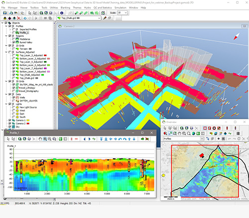
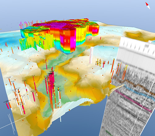
Being able to rapidly visualize data together in 2D and 3D brings clarity and understanding to even complex data.

Modules & Extensions
GeoScene3D is offered as a series of modules and extensions. This enables the end user to tailor the software to the organizational needs.
GET LATEST VERSION
GeoScene3D including documentation and demo projects.
As a new user you can test the full GeoScene3D package for free
with a trial license valid for two weeks
Share your results
Communicate your insights with anyone in your organisation by exporting and displaying cross sections, renders, scenes, and movies in 2D and 3D.
Data Types & Formats
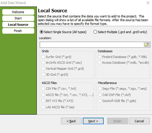
GeoScene3D support a variety of data types and have import wizards in place, making it easy to visualize your data.
Easy to use
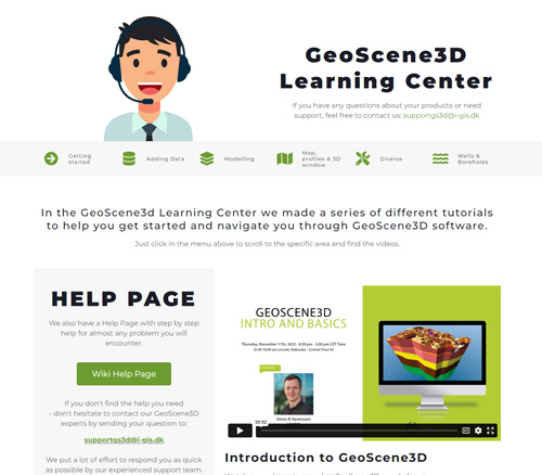
In the GeoScene3D Learning Center you'll find a wide selection of video tutorials and an online Wiki-page, which will guide you through GeoScene3D's functionalities.
Furthermore, we have free online support, typically answering within a few hours. No tickets or registration needed - just write us.
FEATURE
OVERVIEW
Spend your time testing ideas and making the best decisions with streamlined workflows and tools designed for geologists.

FAST MODEL
TOOLS
- Quick Results for you & your clients.
Geophysical mapping used for hydrostratigraphic modeling has been advancing, increasing data volume and resolution.
However, this evolution pressures systems and data interpreters. Clients need quick results. That’s why we developed "Fast Models" tools - to speed up data processing.
PRICING &
SUBSCRIPTION OPTIONS
Our subscription options are flexible and scalable to fit your needs,
providing easy access and reducing costs.
All our products can be accessed under several different subscription types. Detailed below are the subscription options, each structured for the different needs and requirements of our client’s and the geoscience community.
GeoScene3D licenses are bought for a minimum of 1 year. After the first year, an annual subscription is required to keep the license active. Prices includes support by phone, email or online, and free access to tutorial videos. A license is personal and must be installed on one specific computer.
Standard License
GeoScene3D comes in different versions and can be customized according to your needs. A free Viewer can be downloaded from our web page, giving acces to existing GeoScene3D projects. Seting up your own projects requires from a GeoScene3D Basic and up. Price starts from 4550 €.
Customized license
GeoScene3D can be customized by adding extensions and modules. Please contact us for further details.
Discounts are given at different levels, depending on the number of GeoScene3D Basic licenses.
Academic licenses are free for students for non-commercial projects.
Rent a license
Licenses can be rented on a monthly basis. Please contact us for further information.
REQUIREMENTS
System Requirements
We recommend you use either Windows 10 / 11, with a reasonably fast processor, mid range graphics and a reasonable amount of system memory.
More Information
Contact us directly at: supportgs3d@i-gis.dk or stop by our GeoScene Learning Center to learn more.
TRY FOR FREE
Test our GeoScene 3D service 14 days for free.
