
Optimize your
resource utilization
by avoiding improper herbicide application. Thereby lowering negative environmental impact and saving money.
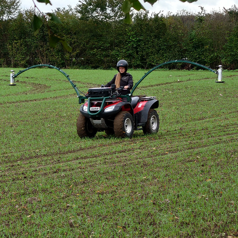
Weed mapping
for your field
The I·GIS mapping services for weeds are designed by agronomists, biologists and IT experts to simplify weed control for farmers. We provide data for weed maps to optimize herbicide treatments.
Involvement
in Agriculture
Since 2013 I∙GIS has been engaging in the agricultural sector to provide custom-made, field-specific, solutions to solve diverse maintenance tasks in agriculture.
Our engagement started by entering diverse collaborations with academia and industry and led to the successful development of systems like RoboWeedMaps and CloverSense.
I∙GIS wants to engage further in the agricultural sector, to help our society and agriculture in a changing environment.
We want to provide tools to use resources thoughtfully, improve the economy, help fulfil legal requirements of pesticide usage and documentation, sustain biodiversity and avoid contamination of our groundwater.
Our interest in agriculture was sparked by our work on the analysis of groundwater reservoirs and their surroundings. The increasing recognition of the importance of clean drinking water and the problem of pollution caused by herbicides came into our focus.
We aim to provide tools for solving current and future agricultural problems, developing solutions to responsibly and safely manage possible contaminants, such as nitrogen and herbicides, and making farming more sustainable.
At I∙GIS we develop agricultural tools to manage resources and potential threats. Coupled with our strive to embrace new technologies, we're continuously striving to innovate and offer cutting-edge technologies and services for the agricultural sector.

SOFTWARE SOLUTIONS


Your tool for mapping weeds in the field, reducing costs and herbicide usage


Evaluate your clover-grassland and determining the optimal fertilization plan
RESEARCH &
DEVELOPMENT
At I∙GIS, research and development is woven into our DNA. We are committed to advance the agricultural sector through innovative solutions, and have collaborated with several research facilities, universities and companies to achieve this goal. Our focus lies on developing technologies that optimize the usage of herbicides and fertilizers in agriculture, providing benefits for both farmers' economy and the environment. We have unique knowledge and products, as well as services, that set us apart in the industry.
Our openness to collaboration and research and development projects is what drives us forward, and we are always looking for new opportunities to partner with others in the field, be it in Denmark or beyond. Our world-class web-based annotation system, powerful machine learning system, and extensive database position us at the forefront of agricultural innovation.
Our team of engaged developers work hard to provide our partners with software solutions for their projects and their customers, e.g. agricultural consultants, farmers, universities and municipalities.
We invite you to join us on this journey of discovery and progress.
Camera systems
Furthermore, we are happy to help with equipment development and implementation of field trials. Recently, we have started a limited production of camera systems for the current RWM ATW image acquisition system, which is also available for purchase for third parties.
For more information contact us at agro@i-gis.dk


CASES
Agrointelli: Robotti


Robottii runs in diverse crops, at daytime, at nighttime and with different purposes (e.g. mechanical weeding, crop monitoring, herbicide application). Trials for different purposes (e.g. fungal infection recognition, emerging crop plant recognition among others) are run at Agrointelli, and I•GIS contributes with model improvement and image analysis.
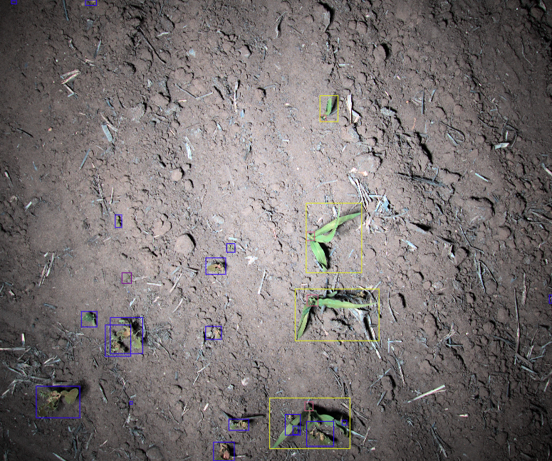
Creeping Thistle recognition


As one of the most problematic weeds in agriculture, creeping thistle (Cirsium arvense) is a focal point of agricultural herbicide treatments. Being a perennial plant with deep rooting systems, distributing widely and most efficiently via seeds, and expensive to treat, their recognition in the RWM maps database was an early focal point. 
The recognition of thistles in RWM is well established and results in great maps which help the farmer find the weed in the field, enhancing the treatment possibilities and decision making. Spot spraying maps for creeping thistle can be provided upon request.
Weed Mapping: High density crop and small weeds

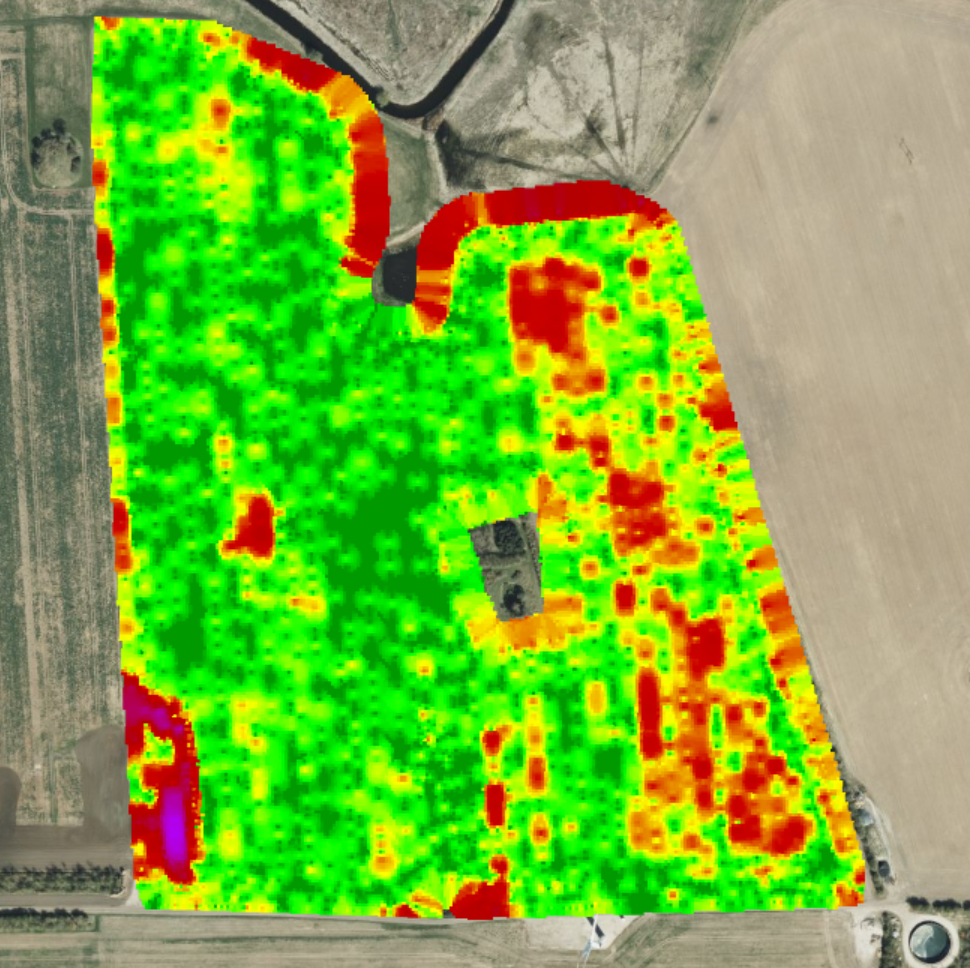
In this field in western Sjælland, we observed a very dense growth of cereal crops. The images were taken at the end of March 2019, when the crop had already started recovering from winter. The image to the right shows the interpolated map calculated based on the individual image results for dicotyledon weeds.
Interestingly you can see the old field ways/borders in the field.
Highlights:
- Few creeping thistles (Cirsium arvense). Spots in the field widely spread.
- Several spots with high density of Cleavers (Galium aparine).
- Possibility of spot spraying for dicotyledon and monocotyledon weeds.